The forum for general posting. Come join the madness.

-
jaybee
- Posts: 1922
- Joined: Mon Oct 08, 2007 8:44 pm
- Location: Knoxville, TN
#26
Post
by jaybee » Wed Mar 19, 2014 8:01 am
andyrinny wrote:
For some reason, the possible circle of the plane's location at 5:11, 6:11, 7:11. etc. has not been released. That would help determine the plane's flight path throughout that period.
I've wondered about that too. They show just one arc (divided into northern and southern parts) from just the 8:11 transmission. It would seem logical that the earlier transmissions would show different arcs and that combining those results would at least narrow down the possible flight path.
Now if you want a conspiracy theory then how about this one: In this modern electronic age we kind of assume that all countries know exactly what is going on around them. If a passenger jet can go undetected, then it's safe to assume that an invading military flight could also remain hidden. So maybe some of the information that is released is just a tad 'optimistic" so as to not appear that various countries in these parts of the world have inadequate radar coverage to protect them in a possible military situation.
Jaybee
-
Bob Juch
- Posts: 27133
- Joined: Mon Oct 08, 2007 11:58 am
- Location: Oro Valley, Arizona
-
Contact:
#27
Post
by Bob Juch » Wed Mar 19, 2014 9:21 am
jaybee wrote:andyrinny wrote:
For some reason, the possible circle of the plane's location at 5:11, 6:11, 7:11. etc. has not been released. That would help determine the plane's flight path throughout that period.
I've wondered about that too. They show just one arc (divided into northern and southern parts) from just the 8:11 transmission. It would seem logical that the earlier transmissions would show different arcs and that combining those results would at least narrow down the possible flight path.
Now if you want a conspiracy theory then how about this one: In this modern electronic age we kind of assume that all countries know exactly what is going on around them. If a passenger jet can go undetected, then it's safe to assume that an invading military flight could also remain hidden. So maybe some of the information that is released is just a tad 'optimistic" so as to not appear that various countries in these parts of the world have inadequate radar coverage to protect them in a possible military situation.
All that can be determined from the pings is the distance, no other location, so all that can be shown is a plot of the points going north or south.
I may not have gone where I intended to go, but I think I have ended up where I needed to be.
- Douglas Adams (1952 - 2001)
Si fractum non sit, noli id reficere.
Teach a child to be polite and courteous in the home and, when he grows up, he'll never be able to drive in New Jersey.
-
jaybee
- Posts: 1922
- Joined: Mon Oct 08, 2007 8:44 pm
- Location: Knoxville, TN
#28
Post
by jaybee » Wed Mar 19, 2014 10:11 am
Bob Juch wrote:jaybee wrote:andyrinny wrote:
For some reason, the possible circle of the plane's location at 5:11, 6:11, 7:11. etc. has not been released. That would help determine the plane's flight path throughout that period.
I've wondered about that too. They show just one arc (divided into northern and southern parts) from just the 8:11 transmission. It would seem logical that the earlier transmissions would show different arcs and that combining those results would at least narrow down the possible flight path.
Now if you want a conspiracy theory then how about this one: In this modern electronic age we kind of assume that all countries know exactly what is going on around them. If a passenger jet can go undetected, then it's safe to assume that an invading military flight could also remain hidden. So maybe some of the information that is released is just a tad 'optimistic" so as to not appear that various countries in these parts of the world have inadequate radar coverage to protect them in a possible military situation.
All that can be determined from the pings is the distance, no other location, so all that can be shown is a plot of the points going north or south.
Wouldn't it make sense though that each set of pings would give a different distance (and thus, a different arc)? Putting the info from 5 arcs of possibility up should eliminate some areas and highlight others as being more probably a course for 370. Just speculating as I certainly don't know much about this system.
Jaybee
-
Bob Juch
- Posts: 27133
- Joined: Mon Oct 08, 2007 11:58 am
- Location: Oro Valley, Arizona
-
Contact:
#29
Post
by Bob Juch » Wed Mar 19, 2014 11:33 am
jaybee wrote:Bob Juch wrote:jaybee wrote:
I've wondered about that too. They show just one arc (divided into northern and southern parts) from just the 8:11 transmission. It would seem logical that the earlier transmissions would show different arcs and that combining those results would at least narrow down the possible flight path.
Now if you want a conspiracy theory then how about this one: In this modern electronic age we kind of assume that all countries know exactly what is going on around them. If a passenger jet can go undetected, then it's safe to assume that an invading military flight could also remain hidden. So maybe some of the information that is released is just a tad 'optimistic" so as to not appear that various countries in these parts of the world have inadequate radar coverage to protect them in a possible military situation.
All that can be determined from the pings is the distance, no other location, so all that can be shown is a plot of the points going north or south.
Wouldn't it make sense though that each set of pings would give a different distance (and thus, a different arc)? Putting the info from 5 arcs of possibility up should eliminate some areas and highlight others as being more probably a course for 370. Just speculating as I certainly don't know much about this system.
That's what they did but there are just two arcs.
I may not have gone where I intended to go, but I think I have ended up where I needed to be.
- Douglas Adams (1952 - 2001)
Si fractum non sit, noli id reficere.
Teach a child to be polite and courteous in the home and, when he grows up, he'll never be able to drive in New Jersey.
-
christie1111
- 11:11
- Posts: 11630
- Joined: Tue Oct 09, 2007 8:54 am
- Location: CT
#30
Post
by christie1111 » Wed Mar 19, 2014 1:28 pm
mrkelley23 wrote:I prefer
this explanation, as it is less "10-impossible-things-before-breakfast"-ish.
That was very interesting to read. I wonder....
"A bed without a quilt is like the sky without stars"
-
andyrinny
- Posts: 183
- Joined: Fri Jul 17, 2009 9:38 am
#31
Post
by andyrinny » Wed Mar 19, 2014 1:41 pm
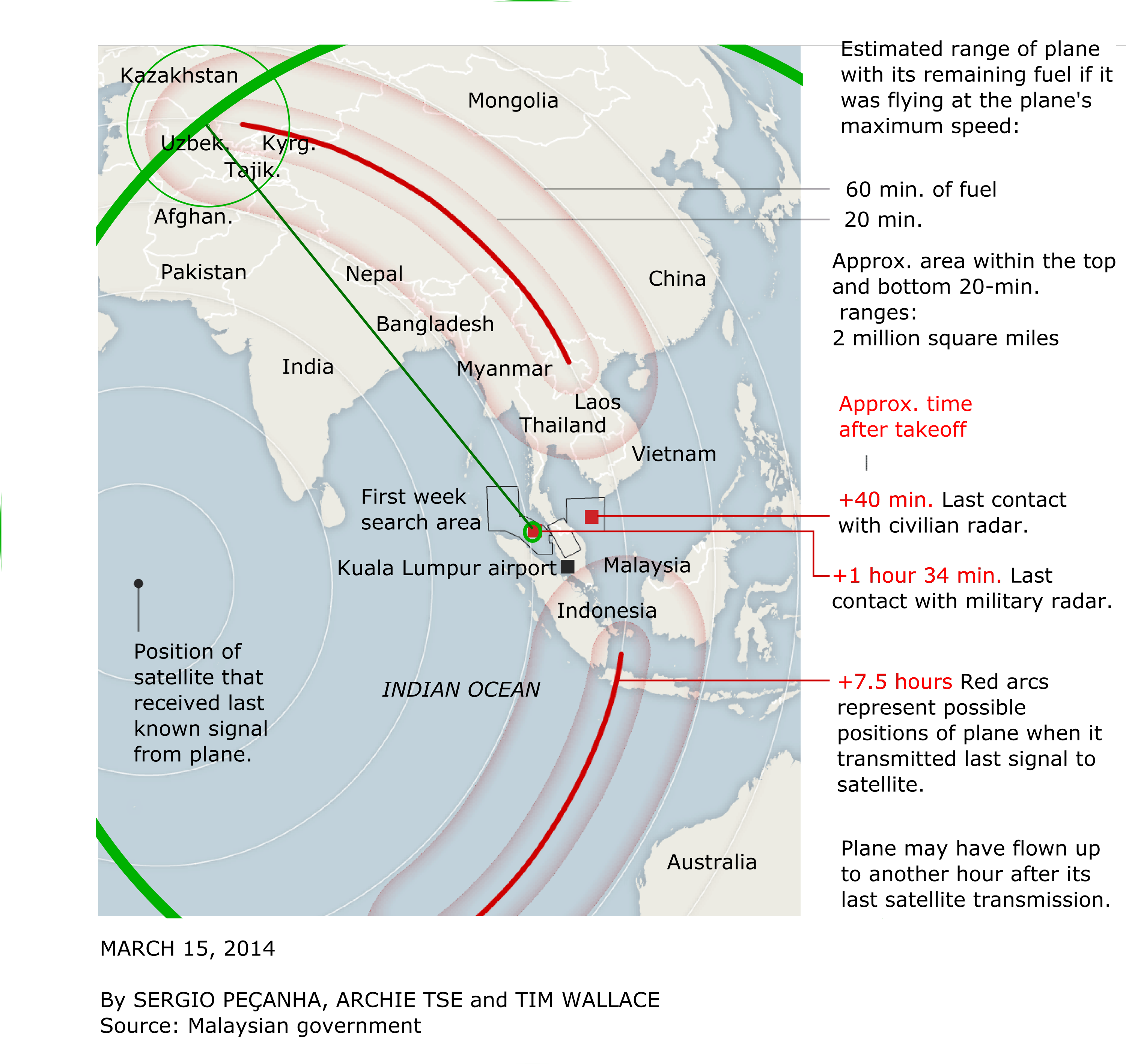
The Inmarsat satellite is in geosynchronous orbit over a certain spot in the Indian Ocean. The satellite effectively recorded the distance between it and the plane on an hourly basis (4:11 a.m., 5:11 a.m., 6:11 a.m., etc.). Thus, the satellite data should show whether the plane, during each hourly segment of its flight, flew generally towards, or generally away from, that spot in the Indian Ocean. This information would be hugely helpful in narrowing the possible flight paths the plane took.
-
Bob Juch
- Posts: 27133
- Joined: Mon Oct 08, 2007 11:58 am
- Location: Oro Valley, Arizona
-
Contact:
#32
Post
by Bob Juch » Wed Mar 19, 2014 1:52 pm
andyrinny wrote:The Inmarsat satellite is in geosynchronous orbit over a certain spot in the Indian Ocean. The satellite effectively recorded the distance between it and the plane on an hourly basis (4:11 a.m., 5:11 a.m., 6:11 a.m., etc.). Thus, the satellite data should show whether the plane, during each hourly segment of its flight, flew generally towards, or generally away from, that spot in the Indian Ocean. This information would be hugely helpful in narrowing the possible flight paths the plane took.
What "spot in the Indian Ocean"? All it can do is to say how far from the satellite the transmitter was.
I may not have gone where I intended to go, but I think I have ended up where I needed to be.
- Douglas Adams (1952 - 2001)
Si fractum non sit, noli id reficere.
Teach a child to be polite and courteous in the home and, when he grows up, he'll never be able to drive in New Jersey.
-
Bob78164
- Bored Moderator
- Posts: 22160
- Joined: Mon Oct 08, 2007 12:02 pm
- Location: By the phone
#34
Post
by Bob78164 » Fri Mar 21, 2014 11:37 am
Bob Juch wrote:andyrinny wrote:The Inmarsat satellite is in geosynchronous orbit over a certain spot in the Indian Ocean. The satellite effectively recorded the distance between it and the plane on an hourly basis (4:11 a.m., 5:11 a.m., 6:11 a.m., etc.). Thus, the satellite data should show whether the plane, during each hourly segment of its flight, flew generally towards, or generally away from, that spot in the Indian Ocean. This information would be hugely helpful in narrowing the possible flight paths the plane took.
What "spot in the Indian Ocean"? All it can do is to say how far from the satellite the transmitter was.
That still gets you an arc on the ground with only a couple of miles of uncertainty (depending on the plane's altitude). --Bob
"Question with boldness even the existence of a God; because, if there be one, he must more approve of the homage of reason than that of blindfolded fear." Thomas Jefferson
-
jaybee
- Posts: 1922
- Joined: Mon Oct 08, 2007 8:44 pm
- Location: Knoxville, TN
#35
Post
by jaybee » Fri Mar 21, 2014 5:59 pm
Bob78164 wrote:Bob Juch wrote:andyrinny wrote:The Inmarsat satellite is in geosynchronous orbit over a certain spot in the Indian Ocean. The satellite effectively recorded the distance between it and the plane on an hourly basis (4:11 a.m., 5:11 a.m., 6:11 a.m., etc.). Thus, the satellite data should show whether the plane, during each hourly segment of its flight, flew generally towards, or generally away from, that spot in the Indian Ocean. This information would be hugely helpful in narrowing the possible flight paths the plane took.
What "spot in the Indian Ocean"? All it can do is to say how far from the satellite the transmitter was.
That still gets you an arc on the ground with only a couple of miles of uncertainty (depending on the plane's altitude). --Bob
Call me confused but I can see one ping giving one distance reading and making one arc. But unless the plane stayed exactly the same distance from the satellite (meaning it was following that arc as it's flight path) the hourly pings should be showing a different distance from the satellite. With five pings, there should be five arcs with possible intersecting points showing an approximate flight path.
I'd welcome any insight, maybe I'm missing something here but I do understand navigation and math.
Jaybee
-
jarnon
- Posts: 7007
- Joined: Tue Oct 09, 2007 9:52 pm
- Location: Merion, Pa.
#36
Post
by jarnon » Fri Mar 21, 2014 6:27 pm
confused wrote:I can see one ping giving one distance reading and making one arc. But unless the plane stayed exactly the same distance from the satellite (meaning it was following that arc as it's flight path) the hourly pings should be showing a different distance from the satellite. With five pings, there should be five arcs with possible intersecting points showing an approximate flight path.
I'd welcome any insight, maybe I'm missing something here but I do understand navigation and math.
The satellite is geostationary, so the arcs are all concentric.
I found this picture online that shows the location of the sub-satellite point and the arcs for various distances from the satellite.
Unfortunately, the plane's assumed flight path was southwest, parallel to the arcs. But let's say it took a different route, such as due west. Every hour, it would be on a different arc. The last arc would be the one closest to the crash site.
Слава Україні!
-
jaybee
- Posts: 1922
- Joined: Mon Oct 08, 2007 8:44 pm
- Location: Knoxville, TN
#37
Post
by jaybee » Fri Mar 21, 2014 7:47 pm
Just read an article (in Slate) that says the arc that has been publicized is just the 8:11 ping. If that's true, then that answers my question.
Jaybee
-
SpacemanSpiff
- Posts: 2487
- Joined: Wed Jul 08, 2009 1:33 pm
- Location: Richmond VA
-
Contact:
#38
Post
by SpacemanSpiff » Mon Mar 24, 2014 8:32 am
Seems as if what was lost is now found.
The strange thing to me is that if the pilot wanted to do himself in (the heck with everyone else), why not crash it straight down instead of running it until it ran out of fuel? I mean, it looks like the dang thing was almost closer to Antarctica than it was to Australia (and certainly way away from the point of last contact).
"If you're dead, you don't have any freedoms at all." - Jason Isbell
-
Bob Juch
- Posts: 27133
- Joined: Mon Oct 08, 2007 11:58 am
- Location: Oro Valley, Arizona
-
Contact:
#39
Post
by Bob Juch » Mon Mar 24, 2014 9:35 am
At 10:00 the Indonesian PM held a new conference in which he said that the plane crashed into the Indian Ocean with no survivors. There is no new evidence of that but it's a good guess.

I may not have gone where I intended to go, but I think I have ended up where I needed to be.
- Douglas Adams (1952 - 2001)
Si fractum non sit, noli id reficere.
Teach a child to be polite and courteous in the home and, when he grows up, he'll never be able to drive in New Jersey.
-
andyrinny
- Posts: 183
- Joined: Fri Jul 17, 2009 9:38 am
#40
Post
by andyrinny » Mon Mar 24, 2014 11:25 am
I continue to be dumbfounded that the authorities have apparently not released the concentric circles showing the possible locations of the plane at 5:11, 6:11, 7:11., etc., and the media has not requested it or made an issue of it. I have watched and read much of the coverage on CNN, and seen no mention of this.
-
jarnon
- Posts: 7007
- Joined: Tue Oct 09, 2007 9:52 pm
- Location: Merion, Pa.
#41
Post
by jarnon » Mon Mar 24, 2014 12:00 pm
andyrinny wrote:I continue to be dumbfounded that the authorities have apparently not released the concentric circles showing the possible locations of the plane at 5:11, 6:11, 7:11., etc., and the media has not requested it or made an issue of it. I have watched and read much of the coverage on CNN, and seen no mention of this.
See my post with a map above. The assumed southwesterly path of the aircraft is approximately along one of the arcs. If it wasn't, somebody would have mentioned it by now.
Слава Україні!
-
flockofseagulls104
- Posts: 9378
- Joined: Mon Oct 08, 2007 8:07 pm
- Location: Atlanta, GA
#42
Post
by flockofseagulls104 » Mon Mar 24, 2014 12:15 pm
If we're comparing it to TV shows, it could also be the setup for the next 24 series.
Your friendly neighborhood racist. On the waiting list to be a nazi. Designated an honorary snowflake... Always typical, unlike others.., Fulminator, Hopelessly in the tank for trump... inappropriate... Probably a tucking sexist, too... A clear and present threat to The Future Of Our Democracy.. Doesn't understand anything... Made the trump apologist and enabler playoffs... Heathen bastard... Knows nothing about history... Liar.... don't know much about statistics and polling... Nothing at all about biology... Ignorant Bigot... Potential Future Pariah... Big Nerd... Spiraling, Anti-Trans Bigot.. A Lunatic AND a Bigot.. Very Ignorant of the World in General... Sounds deranged... Fake Christian... Weird... has the mind of a child... Simpleton... gullible idiot... a coward who can't face facts... insufferable and obnoxious dumbass... the usual dum dum... idolatrous donkey-person!... Mouth-breathing moron... Dildo... Inferior thinker... flailing hypocrite... piece of shit
-
plasticene
- Posts: 1486
- Joined: Mon Oct 08, 2007 3:02 pm
- Location: Los Angeles
#43
Post
by plasticene » Mon Mar 24, 2014 12:49 pm
jarnon wrote:andyrinny wrote:I continue to be dumbfounded that the authorities have apparently not released the concentric circles showing the possible locations of the plane at 5:11, 6:11, 7:11., etc., and the media has not requested it or made an issue of it. I have watched and read much of the coverage on CNN, and seen no mention of this.
See my post with a map above. The assumed southwesterly path of the aircraft is approximately along one of the arcs. If it wasn't, somebody would have mentioned it by now.
That doesn't address his concern at all. The only ping that map considers is the 8:11 ping.
andyrinny is right that it hasn't been given much attention, but people actually have looked at the earlier pings and drawn some conclusions about the flight path:
http://www.slate.com/blogs/future_tense/2014/03/21/mh370_new_inmarsat_data_narrows_missing_airliner_s_flight_path.html wrote:The revelation left a burning question unresolved: what about the six earlier pings, which had been exchanged between the aircraft and the satellite about once per hour? Could any position data be deduced from them?
Today, Inmarsat revealed some crucial information. “The ping timings got longer,” Inmarsat spokesman Chris McLaughlin stated via email. That is to say, at each stage of its journey, the aircraft got progressively farther away from the geostationary satellite’s position, located over a spot on the equator south of Pakistan, and never changed its heading in a direction that took it closer—at least for very long.
-
andyrinny
- Posts: 183
- Joined: Fri Jul 17, 2009 9:38 am
#44
Post
by andyrinny » Mon Mar 24, 2014 1:41 pm
Thanks, plasticene. At least one person - the writer and blogger Jeff Wise you cite - is working the Inmarsat angle. After the March 21 article you linked to, Wise followed up with a longer article on March 22:
http://jeffwise.net/2014/03/22/why-we-n ... ght-route/
Apparently, it has been publicly revealed that the 2:11 ping corresponded closely with the plane's last sighting on military radar. And Inmarsat told Wise that each successive ping was farther and farther away from the Inmarsat satellite. So, if it is assumed that the plane flew on a mostly straight line from 2:11 (or sometime reasonably soon thereafter) to 8:11, there is only a limited range of flight paths the plane could have taken, including one that is largely northward and another that is largely southward.
Wise's article suggests that data for the pings between 2:11 and 8:11 has been analyzed by the NTSB, which mapped likely southward routes and provided that map to the Washington Post:
http://www.washingtonpost.com/national/ ... aphic.html
-
TheConfessor
- Posts: 6462
- Joined: Mon Oct 08, 2007 1:11 pm
#45
Post
by TheConfessor » Mon Mar 24, 2014 1:54 pm
Bob Juch wrote:At 10:00 the Indonesian PM held a new conference in which he said that the plane crashed into the Indian Ocean with no survivors. There is no new evidence of that but it's a good guess.
Not the Indonesian PM. Malaysian PM.
-
smilergrogan
- Posts: 1529
- Joined: Thu Jan 24, 2008 1:22 pm
- Location: under a big W
#46
Post
by smilergrogan » Mon Mar 24, 2014 2:20 pm
Maybe they should try shouting "La-la-la-la-lei!"

-
jarnon
- Posts: 7007
- Joined: Tue Oct 09, 2007 9:52 pm
- Location: Merion, Pa.
#47
Post
by jarnon » Mon Mar 24, 2014 2:30 pm
Thanks, andyrinny. That map is more exact and informative than the one I found.
Слава Україні!
-
plasticene
- Posts: 1486
- Joined: Mon Oct 08, 2007 3:02 pm
- Location: Los Angeles
#48
Post
by plasticene » Mon Mar 24, 2014 3:38 pm
That map is great, but can those really be the right arcs? The Inmarsat spokesperson said that the ping timings got successively longer, but the 5:11 arc on the map is much closer to the satellite than the point of last radar contact, which was apparently not long after 2:11. It seems like the 6:11 arc is around where the 2:11 arc ought to be, and the rest should be inside the band between the 6:11 and 8:11 arcs.
-
Bob Juch
- Posts: 27133
- Joined: Mon Oct 08, 2007 11:58 am
- Location: Oro Valley, Arizona
-
Contact:
#49
Post
by Bob Juch » Mon Mar 24, 2014 4:12 pm
TheConfessor wrote:Bob Juch wrote:At 10:00 the Indonesian PM held a new conference in which he said that the plane crashed into the Indian Ocean with no survivors. There is no new evidence of that but it's a good guess.
Not the Indonesian PM. Malaysian PM.
What would I do without you?
I may not have gone where I intended to go, but I think I have ended up where I needed to be.
- Douglas Adams (1952 - 2001)
Si fractum non sit, noli id reficere.
Teach a child to be polite and courteous in the home and, when he grows up, he'll never be able to drive in New Jersey.
-
Bob Juch
- Posts: 27133
- Joined: Mon Oct 08, 2007 11:58 am
- Location: Oro Valley, Arizona
-
Contact:
#50
Post
by Bob Juch » Mon Mar 24, 2014 4:17 pm
plasticene wrote:That map is great, but can those really be the right arcs? The Inmarsat spokesperson said that the ping timings got successively longer, but the 5:11 arc on the map is much closer to the satellite than the point of last radar contact, which was apparently not long after 2:11. It seems like the 6:11 arc is around where the 2:11 arc ought to be, and the rest should be inside the band between the 6:11 and 8:11 arcs.
We don't know how far away the 2:11, 3:11, and 4:11 pings were. Based on the map, they probably were about the same distance.
I may not have gone where I intended to go, but I think I have ended up where I needed to be.
- Douglas Adams (1952 - 2001)
Si fractum non sit, noli id reficere.
Teach a child to be polite and courteous in the home and, when he grows up, he'll never be able to drive in New Jersey.